GULF SHORES — An updated traffic analysis on the Gulf Pines neighborhood indicated East 2nd Street and East 3rd Street saw an average of 4,000 to 5,000 vehicles a day this spring.
The …
This item is available in full to subscribers.
Please log in to continue |
GULF SHORES — An updated traffic analysis on the Gulf Pines neighborhood indicated East 2nd Street and East 3rd Street saw an average of 4,000 to 5,000 vehicles a day this spring.
The analysis was presented at the Aug. 4 Gulf Shores City Council meeting by Geoff Warr with Jacobs, the company conducting the traffic study throughout the neighborhood after a detour was created for construction to begin on the pedestrian bridge.
Warr said 2nd and 3rd Streets saw the most traffic, according to their traffic counts over this year's spring break and regular school season.
These roads also showed some of the higher recorded speeds as drivers went an average 33.3 mph on 2nd and 32.7 mph on 3rd.
All other streets in the Gulf Pines neighborhood saw an average of under 1,000 vehicles a day. Recorded speeds were an average of 29.5 mph across all streets in the area.
Away from the main detour route, East 22nd Avenue saw the most activity with an average of 500 vehicles a day and reported one of the higher speed zones with drivers going an average 33 mph.
Warr said the numbers for recorded speeds were not "considered off the charts" as they normally only flag speeds 10 mph over the posted speed limit.
He said Jacobs is going to continue monitoring speeds and traffic flows as the area develops.
Since this is the first study done examining traffic in the neighborhood from the detour, no baseline was provided to show how many vehicles traveled each street before it went into place. In a previous GCM article announcing the Jacobs traffic analysis, it showed more than 90% of the traffic used East 2nd and 3rd streets and did not drive deeper into the neighborhood, and the 10% was attributed to "residents, deliveries and that sort of thing."
The state transportation department previously reported both Canal Road and Highway 59 saw a decrease in traffic since the Foley Beach Express Bridge toll station in Orange Beach was removed last year.
Warr said safety is being looked at in three categories, including sidewalk enhancements, pedestrian crosswalks and traffic control changes.
He encouraged the city to expand the sidewalk width from 5 feet to 10 feet and place buffers between the roads and sidewalks. He said buffers could include angled parking, a raised buffer, landscape buffers or decorative fencing.
"Anything to separate the pedestrians from the moving lanes of traffic will enhance their comfort and their sense of safety," he said.
Warr said Jacobs and the city are looking at creating raised pedestrian crosswalks that look like a wide speed bump. They are also looking at potentially adding fully raised intersections to slow traffic.
They are looking at adding the raised pedestrian crossings along East 4th Street including the intersections at East 22nd Street, East 23rd Street and East 24th Street.
For traffic control changes, Warr said, normally more all-way stops are added to an area, which he typically hesitates to do as more stop signs often cause "compliance problems." However, he said more all-way stops "makes sense" around the Meyer Park area.
He also suggested a "realigned all-way stop," which diverts out the road, slightly causing traffic to slow or drive cautious.
"It kind of helps to mitigate that stop-sign compliance by making that driver have to come up to a turn at the intersection rather than being able to blow straight through," he said.
Gulf Shores City Engineer Jenny Wolfschlag told GCM she and Jacobs are working on a memo for council to approve potentially at the Aug. 11 meeting, which was after press time. The memo is to request approval to install all-way stops for intersections on East 4th Street at East 22nd and 23rd avenues and another at the East 3rd Street/23rd Avenue intersection.
She said, at the Aug. 4 meeting, the city will also look at adding shrubbery in certain areas to serve as buffers and continue evaluating design options, traffic control and pedestrian safety measures.
"We're looking city-wide for some of those options," Wolfschlag said. "We want to be able to — with whatever we design here — to carry over to other neighborhoods in the city where we might have some similar problems."
She said the city has already implemented golf cart access to the Gulf Pines neighborhood; improvements to the crosswalk on East 5th Street; signs on East 22nd and 24th avenues stating "Local Traffic Only"; diagonal parking next to Meyer Park on East 3rd Street; intermittent use of speed radar signage; and increased police patrol.
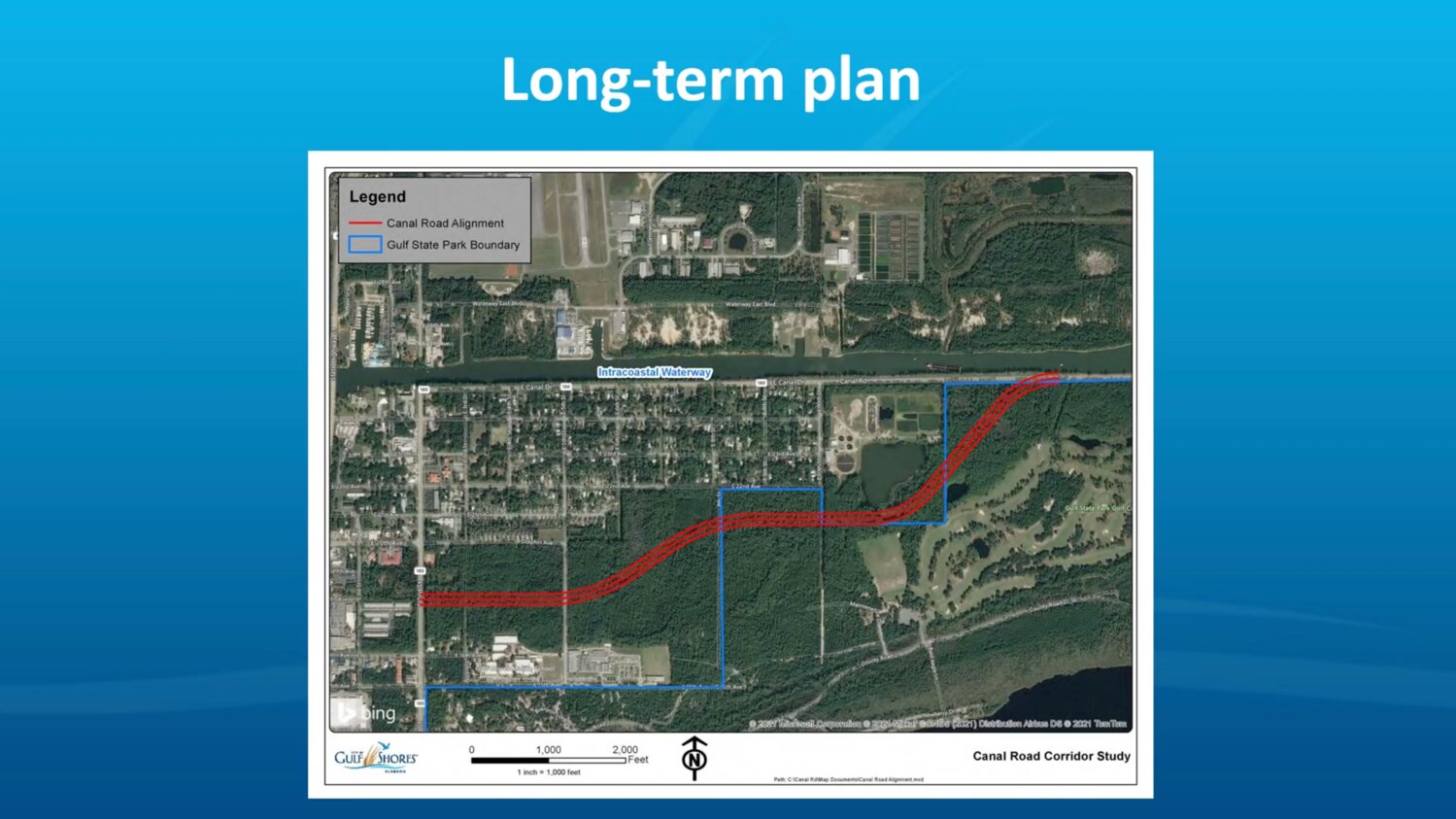
Phase 1 of the long-term plan for the pedestrian bridge is to use Dolphin Avenue and East 10th Street to "bypass a majority of the neighborhood" instead of the current detour through it.
"We haven't proceeded with this option at this point because we are in the right-of-way acquisition phase," Wolfschlag said. "So, we're working on getting the right of way acquired to make that connection from Dolphin up to 10th Street, then we can work on some engineered plans for that."
Phase 2, or the "ultimate, final alignment long-term plan," bypasses the neighborhood entirely. The final road is projected to be created on East 2nd Street, south of Dolphin Avenue, and connect to Canal Road a few blocks past East 10th Street.
Wolfschlag said the city is acquiring the property needed for that project and will then design how it will cross existing intersections.