

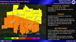
Baldwin County residents and visitors should prepare for severe weather Monday night. In an update provided by the U.S. National Weather Service-Mobile office and the National Oceanic and Atmospheric Administration (NOAA), the imminent arrival of an anomalous weather system encourages attention and preparedness.
As the week begins, an anomaly in weather patterns is set to unleash a series of impactful events, with the biggest impacts anticipated during the overnight hours.
Baldwin County Public Schools announced the cancellation of after-school activites Monday.
"With the threat going up significantly late this afternoon and tonight, we have decided to cancel all after-school activities for today. This includes any sporting events and professional meetings," a Facebook post said.
Additionally, the Alabama Law Enforcement Agency (ALEA) asks for citizens and visitors to make preparations now by adjusting travel plans.
“At any moment, weather conditions can change drastically,” ALEA’s Secretary Hal Taylor said. “Forecasters continue to predict severe weather that could have dramatic impacts across our state, but especially the southern portion over the next 48 hours. Our Agency stands ready to assist with all divisions and units developing and implementing severe weather operation plans for this storm system. However, we strongly encourage and recommend that both citizens and visitors prepare now for the incoming weather. In the event conditions worsen, we urge motorists to adjust travel plans and avoid driving in severe weather if possible.”
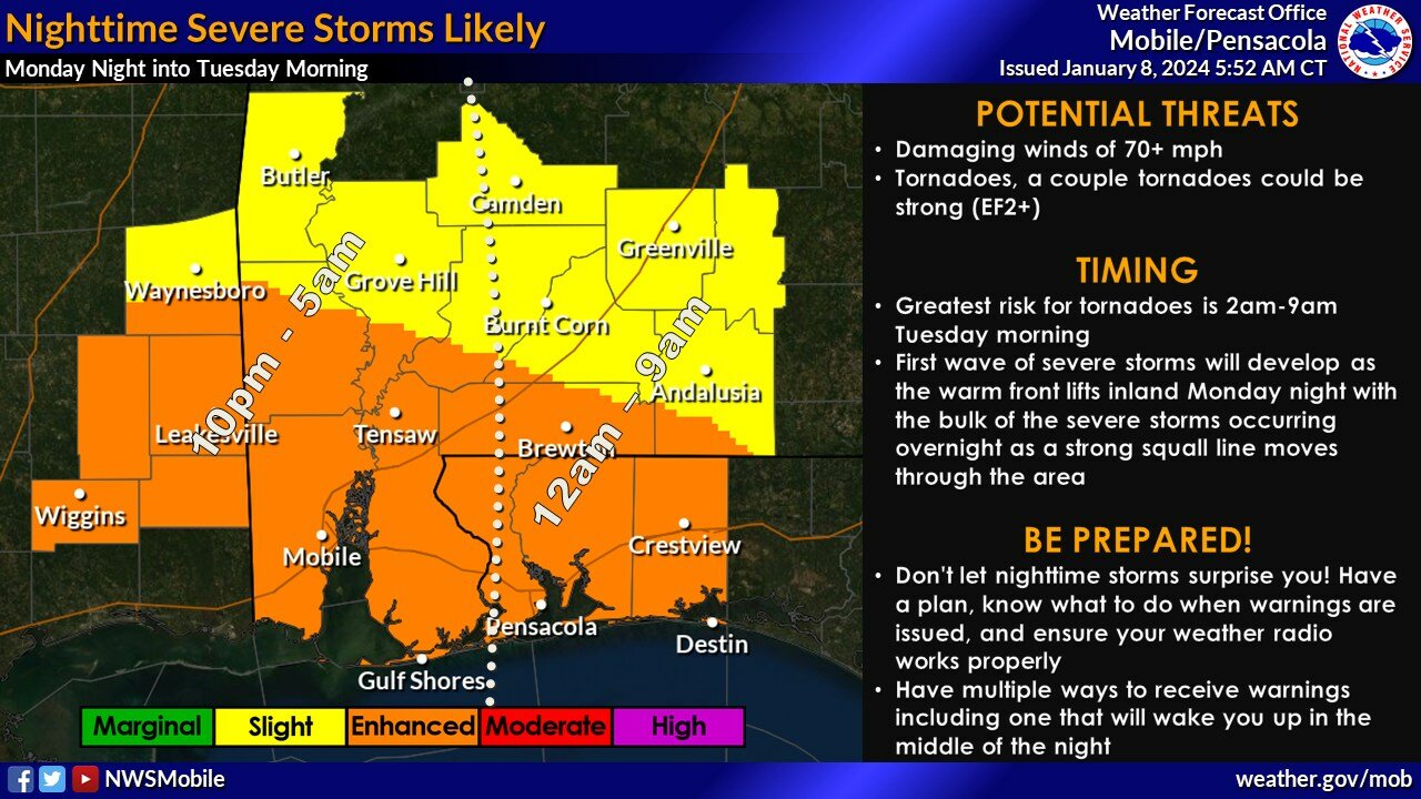
Severe Threat:
Severe storms forecasted will be characterized by damaging winds exceeding 70 miles per hour and the potential for tornadoes, including some potentially strong (EF2+). The highest tornado threat is anticipated from 2 to 9 a.m. on Tuesday, Jan. 9. Conditions are expected to deteriorate rapidly during this period, transitioning from isolated storms to widespread severe storms.
An initial wave of rain showers from the Gulf of Mexico on Monday afternoon is not a primary concern, though always keep safety in mind.
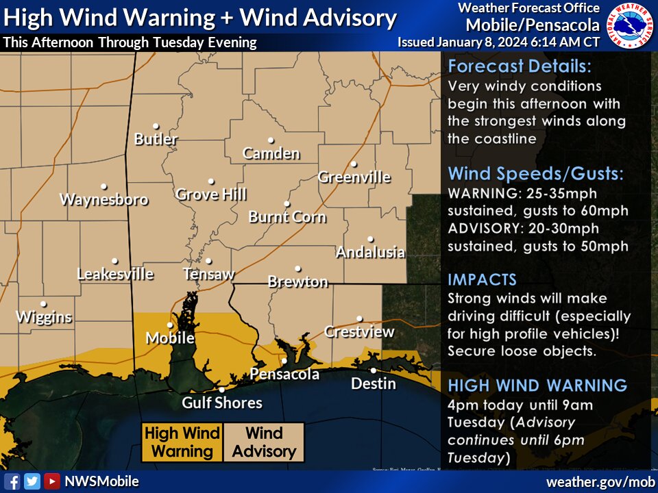
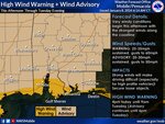
Strong Winds:
Widespread windy conditions are forecasted from Monday afternoon, particularly intense along the coast, with gusts up to 60 mph. A High Wind Warning is in effect from 4 p.m. Monday, Jan. 8, to 9 a.m. Tuesday, with NWS meterologists anticipating south winds at 25 to 35 mph with gusts up to 60 mph. Damaging winds pose risks to trees, power lines and may lead to widespread power outages and challenging travel conditions.
Precautionary/Preparedness Actions: Avoid outdoor activities in forested areas and around trees. If possible, remain in the lower levels of your home during the windstorm, and exercise caution when driving, particularly high-profile vehicles. Secure or relocate outdoor items susceptible to wind displacement.
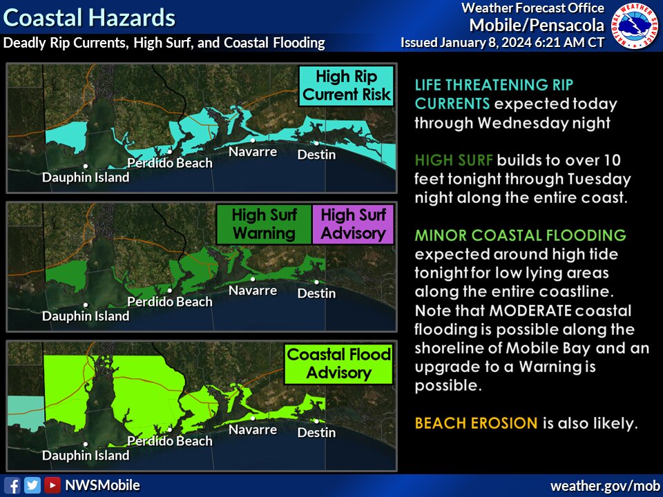
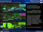
Coastal/Beach Hazards:
Winds will induce numerous coastal impacts, including life-threatening rip currents from Monday through Wednesday night. High surf is expected to build to 10-plus feet from Monday night through Tuesday night. Coastal flooding is anticipated Monday night along the entire coast, with the possibility of upgrading the Coastal Flood Advisory to a Warning, especially along the shoreline of Mobile Bay. Beach erosion is highly likely.
Precautionary/Preparedness Actions: Allow extra time for travel, avoiding driving around barricades or through water of unknown depth, and taking necessary actions to protect flood-prone property.
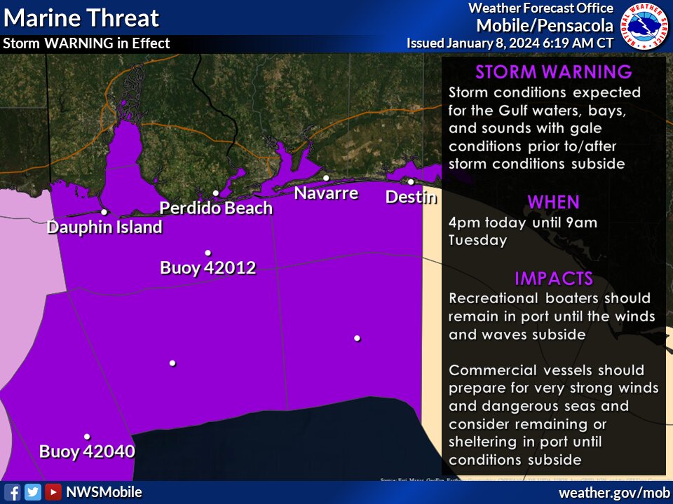
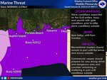
Marine Threat:
A rare Storm Warning is in effect for all Gulf waters, bays, sounds and waterways starting Monday afternoon, with the forecast anticipating sustained winds of 30-40 knots and gusts up to 55 knots.
Notably, this marks only the second Storm Warning issued by the U.S. National Weather Service in Mobile since 1994 for the Gulf waters.
In the face of unpredictable weather patterns and the increasing frequency of extreme events, staying informed and prepared is paramount. Whether it's a hurricane, tornado, or severe winter storm, having a plan in place can make all the difference. Below are crucial tips for emergency weather preparedness. These actionable insights, will empower you to face any storm head-on.
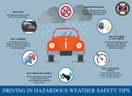
The Alabama Law Enforcement Agency (ALEA) has provided crucial safety guidelines for individuals preparing for inclement weather and navigating hazardous driving conditions. These recommendations aim to ensure public safety and minimize risks during adverse weather events. Here is a comprehensive overview of ALEA's valuable tips:
Preparing for the Storm Reminders:
Before the Storm Tips:
During the Storm Tips:
After the Storm Tips:
By adhering to these tips, individuals can contribute to their safety and the well-being of their communities during and after severe weather incidents.
Nighttime Storm Safety Reminders:
By adhering to these tips, individuals can contribute to their safety and the well-being of their communities during and after severe weather incidents.
Refresh on evacuation routes, tornado shelters and more with Gulf Coast Media's Stay Alert, Baldwin County magaizne.


