
Miami, Fla. – It didn't take long at all for a system out in the far Atlantic to grow through watch status to 'Tropical Depression 5' to the newly-named Tropical Storm Erin. The storm is expected to remain in the Atlantic and diminish its …
This item is available in full to subscribers.
Please log in to continue |
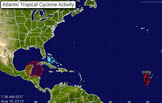
Miami, Fla. – It didn't take long at all for a system out in the far Atlantic to grow through watch status to 'Tropical Depression 5' to the newly-named Tropical Storm Erin. The storm is expected to remain in the Atlantic and diminish its intensity over the next week.
Of more immediate concern is the system off the Yucatan which the National Hurricane Center continues to tag with a 'high' 60% probability of tropical cyclone status. Regardless of that system's status upgrade to a depression or named-storm, forecast models call for the disturbance to generate heavy rainfall amounts streaming into Florida and the southeast over the weekend.
Here's the latest from NHC on that system:
SATELLITE IMAGES AND SURFACE OBSERVATIONS INDICATE THAT THE WEATHER DISTURBANCE IN THE EXTREME NORTHWESTERN CARIBBEAN SEA HAS BECOME LESS ORGANIZED OVERNIGHT WITH MOST OF THE SHOWER ACTIVITY NOW MOVING OVER THE YUCATAN PENINSULA AND BELIZE. DEVELOPMENT OF THIS SYSTEM BEFORE IT MOVES OVER LAND HAS BECOME LESS LIKELY...HOWEVER THERE IS STILL POTENTIAL FOR DEVELOPMENT ONCE THE DISTURBANCE MOVES OVER THE GULF OF MEXICO. THIS SYSTEM HAS A MEDIUM CHANCE...50 PERCENT...OF BECOMING A TROPICAL CYCLONE DURING THE NEXT 48 HOURS...AND A HIGH CHANCE...60 PERCENT...OF BECOMING A TROPICAL CYCLONE DURING THE NEXT 5 DAYS. FIVE-DAY FORMATION PROBABILITIES ARE EXPERIMENTAL IN 2013.


